


UK Offline Road Map - OS Based

Beschreibung von UK Offline Road Map - OS Based
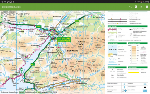
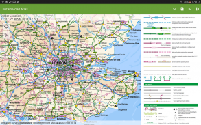
OS (Ordnance Survey) offline map atlas of Great Britain.
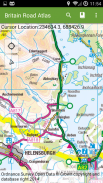
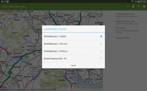
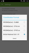
British National Grid coordinates as an option to standard latitude, longitude.
UK Atlas covers England, Wales, Scotland, Orkney, Shetland, Western Isles, Isles of Scilly and Isle of Man. Northern Ireland and the Channel Islands are not covered by this application.
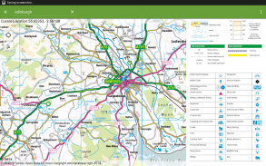
Application provides a regional view of the landscape which is similar in content and appearance to a typical road-atlas.
On the map you can browse:
- Cities, towns, villages, centres of population,
- Motorways and junction numbers, A and B roads,
- Railways,
- Rivers,
- Some woodland features and wind farms location.
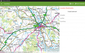
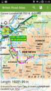
The app is ideal for route planning and geographic context. You can show/follow your current location and calculate distance between points using 'tap' action.
With this app you do not need the paper atlas any more. You will get same level of details - popular OS 1:250K scale and you will be able to check alternative routes just in few seconds.
The application provides support for geographic and British National Grids coordinates - set your default format in settings.
You always know where you are and how to get to your destination.
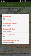
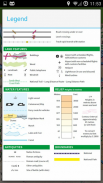
UK Map Atlas contains 1:50 000 Scale Gazetteer which is a GB reference tool and location finder containing 250,000 distinctive place and feature names.
Contains Ordnance Survey Open Data © Crown copyright and database right 2015.
</div> <div jsname="WJz9Hc" style="display:none">OS (Ordnance Survey) offline Karte Atlas of Great Britain.
British National Grid koordiniert als Option zur Standard-Breite, Länge.
UK Atlas umfasst England, Wales, Schottland, Orkney, Shetland, Western Isles, Scilly-Inseln und Isle of Man. Nordirland sowie die Kanalinseln sind nicht Gegenstand des vorliegenden Antrags.
Anwendung bietet eine regionale Blick auf die Landschaft, die ähnlich wie bei Inhalt und Aussehen einer typischen Straße-atlas ist.
Auf der Karte können Sie sehen:
- Städte, Städte, Dörfer, Zentren der Bevölkerung,
- Autobahnen und Anschlussnummern, A- und B-Straßen,
- Eisenbahnen,
- Flüsse,
- Einige Waldfunktionen und Windparks Lage.
Die App ist ideal für die Routenplanung und geographischen Kontext. Sie können zeigen / folgen Sie Ihren aktuellen Standort und berechnen Abstand zwischen den Punkten mit "Tap" Aktion.
Mit dieser App können Sie die Papieratlas mehr benötigen. Sie werden gleiche Maß an Ihr Fahrzeug - populäre OS 1: 250K Skala, und Sie werden in der Lage, alternative Routen nur in wenigen Sekunden zu überprüfen.
Die Anwendung unterstützt die geografische und British National Grid Koordinaten - Ihre Standard-Format in den Einstellungen.
Sie wissen immer, wo Sie sind und wie Sie zu Ihrem Ziel zu gelangen.
Großbritannien Karte Atlas enthält 1.50 000 Skala Gazetteer die ein GB Nachschlagewerk und Positionssucher, die 250.000 unverwechselbaren Platz und Komponentennamen ist.
Enthält Ordnance Survey Open Data © Crown Copyright und Datenbankrecht 2015.</div> <div class="show-more-end">
UK Offline Road Map - OS Based – Version 2.0.0
(21-07-2020)
UK Offline Road Map - OS Based – APK Informationen
APK Version: 2.0.0Paket: com.osedok.britainroadatlasNeueste Version von UK Offline Road Map - OS Based
Weitere Versionen


Apps in derselben Kategorie


Das könnte dir auch gefallen...


